Categories
Archive

The New American City

Researching new relationships between the city and the American landscape

A city is to be composed principally of the habitations of men, and strait-sided and right angled houses are the most cheap to build and the most convenient to live in. The effect of these plain and simple reflections was decisive.
Commissioner’s Plan, New York City, 1811

At a time when the sustainability of urban environments is becoming an ever more urgent issue, and architects and urban thinkers are looking for new planning models, the time seems right to reconsider this relationship between city and territory. Today urban farming is widely promoted as a viable ecological alternative; recycling, barter and self-provisioning are becoming established as alternative economic models. Rust-belt cities of the Midwest are being depopulated, and the role of smaller cities is being re-evaluated, as proximity no longer drives urbanism. Conversely, on the global stage, new cities are being built from scratch in Asia and the Middle East.

The New American City is a prototype urban settlement that works with the geometry of the one-mile square grid. It assumes that porosity to the landscape, the provision of extensive open space and the incorporation of food production need not be inconsistent with higher densities; it assumes that innovative architecture and consistent, legible, urban fabric need not conflict. The New American City accepts the measure and the geometry of the grid as a starting point. The working unit is a one-mile square “quarter” with around 12,500 inhabitants. The proposal assumes that private land ownership will continue to be the dominate pattern in American cities. Density is controlled through a cascading gradation of lot sizes and overall height limitations rather than by elaborate design guidelines. The quarters are populated with an extensive array of different housing types, each one incorporating small-scale food production.

If the Jeffersonian grid represents an agrarian vision based on decentralized settlement, the linear city proposals that began to emerge in the 19th century are based on models of industrial production and distribution. Despite the open-ended quality of the mid-western grid, the American city is often a linear city by default. American cities have always developed along canals, railroads and roadways, and in the last half-century, an extensive transportation infrastructure has underwritten suburban sprawl. The New American City proposal accepts this paradox and imagines a contemporary synthesis, supported by new technologies: the equality and decentralization of the regular grid, overlaid with the hierarchies of a regional transportation infrastructure. Connected to larger networks of communication, small cities in the rural landscape need no longer be condemned to secondary or “provincial” status. The proposal is structured around a regional highway, which acts as an organizing spine and primary circulation. By strictly maintaining the perimeter of the one-mile squares, sprawl is contained. The checkerboard pattern of development assures that each quarter is surrounded by green space on three sides. A network of parkways parallel to the highway irrigates the densely populated squares with movement and green space, providing sites for institutional buildings. Moving away from the central spine, the squares rotate to respond to local geography, as well as to open up large interstitial sites for schools, research or production facilities.

Categories
Archive

Start-up City

This research studio will revisit—and hopefully reinvent—the tradition of imagining a city from scratch. The world’s population is projected to increase by 1.5 Billion in the next 15 years.  Already more than 50% of that population lives in urbanized areas and the percentage is projected to reach 75% in coming decades. In developing countries (where the bulk of the population growth is occurring), the existing urban infrastructure is simply incapable of supporting that level of growth.  Rather than accommodate that population growth in already stressed urban centers, we propose that a more viable strategy would be a series of “Start-up Cities;” small yet diverse cities characterized by innovative design at both the architectural and urban scale.

In order to develop new strategies, we will collectively analyze past examples, and produce designs valid in the present. We will review contemporary urban thought and proposals: New Urbanism, Landscape Urbanism, Infrastructural Urbanism. We will explore new conceptual frameworks opened up by complexity theory and ecological thinking. We will investigate the environmental implications of city design, and pay attention to the ecological impact of these new cities.  Finally, the iterative and serial nature of urban form is well-suited to computational design and we will make full use of new design methods.

Research director: Stan Allen

Categories
Archive

Venice Biennale 2016

City Fragment: Vertical Botanic Garden

The Packard Plant is an elemental work of architecture. Albert Kahn’s Packard Number Ten, completed in 1905, was the first automobile factory to be constructed in reinforced concrete. The Packard Plant is not so much a building as a serial assemblage of parts—columns, slabs, windows, roof. It is the archetypal 20th century space of production. Today it exists as a ruin, preserved almost accidentally, in part due to the strength of its reinforced concrete construction.

Any proposal to repurpose the Packard Plant must come to terms with the hard realities of contemporary Detroit. At one time a dynamic city driven by the prosperity of the automobile industry, today Detroit is scarred by decline. The urban and social landscape has been emptied out by poverty and neglect, and the economic base is fragile. The positive signs of renewal do not scale to the Packard Plant. The site is too remote, the scale too vast and the urban fabric too fragmented. In short the usual urban design strategies will not work here. On the other hand, the assets of the site are extraordinary, beginning with the quality and scale of the architecture itself. This is a radical architecture based on endless repetition and vast horizontal spaces.

Refusing the seduction of the post-industrial ruin, our project looks for opportunities in the elemental character of the architecture itself: a platform for new programs, and new futures for Detroit. The project operates at four interrelated levels: urban; infrastructural; architectural and programmatic. This separation into levels is provisional only, and the parts—like the city itself—form a larger, ‘difficult’ whole. Above all, our approach is fundamentally architectural: these four levels represent four essential dimensions of the architect’s imagination.

A Situation Constructed from Loose and Overlapping Social and Architectural Aggregates

The MOS proposal works with and within the overlapping and disaggregated connections between urban and social form. Situated above and around the Dequindre Cut, it uses a low-rise high-density development – produced through the loose arrangement of empty types, frameworks, and open spaces – to connect existing conditions with a new urban fabric. At grade, a neighborhood of common spaces links the community with the Cut and the existing street system. The structure and circulation are based on the economical model of highway and parking structures. A series of spiral ramps punctuate the structure, connecting all levels with pedestrian and vehicular traffic. A perennial garden and plaza extend across the roof, creating a network of spaces for recreation and social gathering. Thin buildings maximize the surface area of their facades, and in turn maximize daylighting. The emptied typologies serve as an open framework for something else, imagined by someone else, to happen. They are owned collectively, they do not front streets, and they work outside conventional notions of property and lots. The thresholds between interior and exterior – roofs, ramps, porches, and overhangs – provide informal areas for neighbors to commune. Every exterior space is a public space; every interior space is a public space.

Categories
Archive

Roma Interrotta

The MAXII Exhibition

“Roma 20-25: New Life Cycles for the Metropolis”  is an international design workshop and exhibition organized by the MAXXI Foundation and the Urban Planning Department of the City of Rome. Drawing from the 1978 “Roma Interrotta” exhibition, the project calls schools of architecture to envision Rome’s urban future by superimposing a virtual grid to a new map of Rome’s metropolitan area. Rather than dividing the city based on the Nolli plan’s twelve sections, Roma 20-25 generated a new map of Rome by identifying the territory where most of the social and economic activities currently take place. Twenty-five different areas were defined and assigned to participating universities, who were asked to both analyze and re-design their given territories.

“Giro di Roma: The Agency of Architecture at the Urban Scale”

Our approach is governed by three working principles.  First, to engage the question of Rome’s immediate periphery in both its local, historical context as well as the wider context of dispersed urbanisms in the 21st Century.   This suggests a careful attention to infrastructure and mobility: both the movement of goods and people, as well as social mobility. Second, to understand the city today as something not separate from nature but embedded in a larger ecological context; today, the city is in nature and nature is in the city.  This implies a close attention to territory, topography and landscape.  Finally, we want to engage the memory of the 1978 Roma Interrotta exhibition.  Despite the vast scale of the site, we are convinced that the problem of the city belongs to architecture, and that architectural interventions have a real potential for positive agency at the urban scale.

The PUIC team was assigned the central square in the large territorial array, sharpening the exhibition’s focus on questions of center and periphery.  Our focus, however was not on the historic center, but rather on the edges of the given square: the porous mix of landscape and building fabric surrounding Rome’s compact center.

Credits:

Research and Exhibition proposal produced by Princeton’s Center for Architecture, Urbanism and Infrastructure

Stan Allen, Director and project leader                                                       

Research and Design Team:

Julian Harake; Miles Gertler; Alfredo Thiemann; Hans Tursack; Okki Berendschot; Liam Turkle; Princeton University PUIC

Our Approach

Our approach is governed by three working principles:

First, to engage the question of Rome’s immediate periphery in both its local historical context and the wider context of dispersed urbanisms in the 21st Century. This suggests a careful attention to infrastructure and mobility. In order to underscore the idea that the remnants of the historical past are not limited to the center, we propose to mark the concentric order of the city with a new ring, which will be a structured landscape system first while simultaneously operating at the city-wide scale as a device to unify the periphery.

Our second approach is to understand the city today as something not separate from nature but embedded in a larger ecological context.  This implies a close attention to territory, topography and landscape. Working with existing natural pathways (rivers, green corridors and topographical features) we will repair the connectivity of the large-scale natural systems through defined local interventions.

Finally, we want to engage the memory of the 1978 Roma Interrotta exhibition (and its deep Princeton roots). Specifically, departing from Kenneth Frampton’s idea of the “Megaform” – large scale interventions that are characterized by intricate sectional topology and careful relationship to site and landscape – we  believe that it is possible to create local density and social aggregation that is well integrated into this new urban field condition. Despite the vast scale of the site, we are convinced that the problem of the city belongs to architecture, and that local architectural interventions have a real potential for positive agency at the urban scale.

Team members: Julian Harake, Miles Gertler, Alfredo Thiemann

Categories
Archive

Recycling Seoul

An update to the Athens Charter

The object of this research is to produce a comprehensive proposal for the contemporary city: a speculative update of the Athens Charter. We will use Seoul as a paradigmatic case of the contemporary city to test different proposals in a specific urban environment. In this way we manifest the physical and spatial implications of technology on social organizations, urban events, or institutional and economic formations, once applied to an existing physical infrastructure. Members of this research will collaborate with authorities in Seoul Metropolitan Government and other institutions. Students will develop an innovative network of recycled spaces for Seoul through architectural means.

The work will be aimed at envisioning viable reuse of these infrastructures for programs which are created by and for new urban technologies.  We will assign different projects of urban recycling to the different functions of the Athens Charter, in order to test them on a condition of re-use rather than of tabula rasa. The collection of all studio projects will constitute a comprehensive document to be published and exhibited in the first Seoul Architecture Biennale.

Categories
Archive

Cities Within Cities

A study of self-contained urban nodes within existing frameworks

Just as cities today form global networks, individual cities can be understood as a series of interconnected nodes. Urban fabric is granular, not smooth. It is characterized by pockets of intensity that develop around transportation nodes, historic centers, and increasingly, commercial zones. This is not a new phenomenon; The Palais Royale in Paris has been described as an early example of a self-contained urban enclave that never-the-less encompasses all of the dynamism and complexity of the city surrounding it. With new technologies, and an expanded scale of intervention, new urban typologies have emerged: vast enclosed stadia, simulated streets and interconnected urban shopping malls, labyrinthine transit nodes, artificial ski hills and surfing beaches, atria and gardens extending high into the air. The strong separation of exterior and interior disappears, and with it, the sense of the city as a man-made artifact situated in a natural landscape. “Atlanta is not a city, it is a landscape,” Rem Koolhaas has observed. “Its artificiality sometimes makes it hard to tell whether you are inside or outside.” The maximum artificiality of the urban landscape coincides paradoxically with a new sense of the city as continuous with nature.

Cities Within Cities is a collaborative research project that analyses and documents this phenomenon in its historical and contemporary manifestations. The goal is to create a catalogue of examples that might in turn provide models for contemporary urban interventions.

Categories
Archive

SoA Exhibit: Keith Krumwiede, “Freedomland”

Keith Krumwiede’s Freedomland… a satirical settlement scheme that examines the competing goals and desires that define contemporary American culture.

Freedomland is the latest in a long line of visionary plans for American living. It is an experiment in reconciling the seemingly incompatible needs and desires that define our current economic, environmental, and, most importantly, political climate.

Freedomland is the latest in a long line of visionary plans for American living. It is an experiment in reconciling the seemingly incompatible needs and desires that define our current economic, environmental, and, most importantly, political climate. In one bold, absurdist move, Freedomland colonizes the super grid that blankets America, attempting in the process to solve every problem, please every citizen. Like the work of a benevolent (or perhaps delusional) dictator, it seeks to accommodate every wish, every desire, no matter how contradictory and to combine them in a master plan that sets out a beautiful, if seemingly naïve, vision for a better, more harmonious world.

In Freedomland, the American Dream—battered by, even if ultimately responsible for, recent economic events—confronts the reality of increasingly scarce natural resources and a broken social contract. It is utopia of superhomes—communalist phalansteries constructed from consumerist single-family houses—in which collective needs square up with individual desires. Its logic is one of both/and: both Jefferson and Hamilton (founding fathers of our collective split personality); both open and closed; both centralized and decentralized; both individualistic and collectivist; both farm and market; both local and global; both village and villa, and, ultimately, both city and country.

Freedomland is a fiction, of course, a work of architectural satire with no pretense toward implementation. In as much as it is the bastard lovechild of Frank Lloyd Wright and Le Corbusier—think Broadacre City meets the Ville Contemporaine with a dash of Ebenezer Howard’s Garden City thrown in for good measure—there is a key difference. Freedomland is problem seeking not problem solving, diagnostic not prescriptive. It builds its grand vision from the basic, eminently American unit of the single-family house, working up and out by uploading conflicting desires and visions to clarify the issues—socially, environmentally, and, ultimately architecturally—that confront us at this particular moment in time.

View the (link: http://free-dom-land.tumblr.com/ text: Freedomland) tumblr

“Freedomland isn’t free. Keith Krumwiede’s staged utopian earnestness and Jeffersonian grandeur remind us of the pains and costs of McMansions, ranchburgers, and rampant speculation on the amber waves of grain and fruited plains of our manifest destiny. His proposals are at once beautiful and unnerving—an architectural Americana that sticks in our craw because it seems entirely natural and just as equally absurd.”

— Mark Pasnik, *Praxis 14* “True Stories”

Keith Krumwiede is Associate Professor and Director of Graduate Architecture Programs at the College of Architecture and Design at the New Jersey Institute of Technology. He received his B.A. from the University of California at Berkeley and his M.Arch. from the Southern California Institute of Architecture. Current projects include *Gross Domestic Product*, a book about the recent history of the ultimate American consumer product, the single-family house, and *Freedomland: An Architectural Fiction and Its Histories*, a satirical settlement scheme that examines the competing goals and desires that define contemporary American culture. Freedomland has been exhibited at the Woodbury University Hollywood Gallery in Los Angeles and Pinkcomma Gallery in Boston. Recent essays include “The Bauhaus Tweets” in *Log 22: The Absurd* and “(A)Typical Plan(s)” in *Perspecta 43: Taboo*. Prior to teaching at NJIT, he was Assistant Dean at Yale University School of Architecture, where he was awarded the King-Lui Wu Award for Distinguished Teaching.

Categories
Archive

Microcities

Viable alternatives to the megacity phenomenon.

The rapid pace of urbanization over the past two decades has produced megacities of staggering size and complexity. Most are located in the developing world: in China alone there are 5 cities with populations over 10 million. Architects are fascinated with the megacity phenomenon, and have produced vast amounts of documentary research. But the reality is that the discipline of architecture has been powerless in the face of the complex economic, technical, social, political and environmental forces shaping the megacity. Two questions are worth asking: Does it make sense for architects to persist in the naïve belief that they could ever have a meaningful impact on the megacity? And is the proliferation of megacities actually a viable solution to the problems of global urbanism?

Zipf’s law tells us that in any country, the number of very large cities is going to limited. The Microcites research project at the PUIC suggests that architects and urban thinkers might more profitably turn their attention to the opposite scale of urban development: successful small-scale cites with a productive regional presence. The United States Office of Management and Budget has defined 536 micropolitan statistical areas: urban aggregations of between 10,00 and 50,000 population, with at least one urban core and a positive social and economic integration of core and surrounding area. At a time when the small size and agility have become watchwords for innovation, it seems strange that architects would persist in their preoccupation with bigness.

This research sets out to document and understand viable small cites in the US and abroad. Our focus, unlike the OMB, is on the urban core. The research examines how the proliferation of digital technologies and 21st century infrastructures has blurred conventional relationships between city and countryside. Beyond scale, what are the essential characteristics that define a city? What is the smallest viable urban unit? Is it possible to imagine a series of dynamic microcities as a viable response to the social, economic and environmental challenges of global urbanism today?

Categories
Archive

Angelo Bucci on SPBR Projects

Angelo Bucci’s lecture on projects by SPBR is available online! The event was sponsored by PUIC and the Program in Latin American Studies.

Angelo Bucci, founder and principal in charge of SPBR architects, focuses his lecture on showing some of the recent projects by his office, aiming to share the experience of their practice based in the specific context of Sao Paulo in Brazil. The lecture highlights an approach of architecture in relationship with construction and structure but also an approach of a symbolic meaning of designing.

Recordings of lectures taking place in the Princeton’s School of Architecture are available here on the School of Architecture’s Visual Resources Collection.

Video recorded by Dan Claro of the Visual Resources Collection.

Categories
Archive

RECAP LA Workshop: Watershed

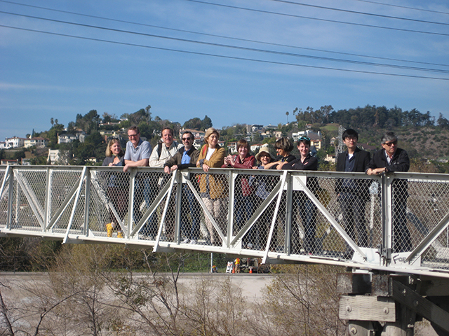
Before arrival in UCLA’s Perloff Hall, conference attendees were given a tour of the Los Angeles river, led by Jenny Price, writer, Los Angeles Urban Ranger, Research Scholar at the U.C.L.A. Center for the Study of Women and recent Anschutz Fellow in American Studies at Princeton University. Attendees were able to literally get their feet wet in a decidedly urban river, providing a shared and very immediate understanding of what hard water infrastructure is like. Through a visit to a comparably unpaved section of the river, they were also given a chance to imagine what the space could become if taken over, softened and greened, providing park space to under-served areas of Los Angeles and adding to the image of the city. Moreover, softening the river bed would increase the water available for human use, instead of sending it out to the ocean as fast as possible, as the hard, paved version does.

The organization of the conference followed the fictional construct of the water cycle. The first panel focused on the movement of water from Air to Surface and back again. Tom Wright, Director of the Regional Plan Association and moderator of the panel, opened by acknowledging his own water dislocation, traveling from an island surrounded by water to a context very much 
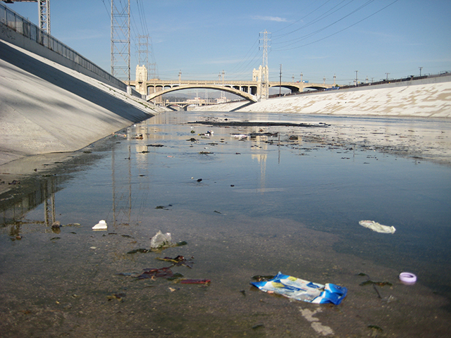
aware of the need to conserve water. Jenny Price then presented a history of the Los Angeles river in her talk, “The LA What??: Paving and Un-paving America’s Most Famous Forgotten River”. While the river was the site of the city’s founding, residents had since turned their backs on the river following its paving by the Army Corps of Engineers. Until 1985, when the friends of the LA River began what has become one of the best funded civic projects, a project of river revitalization by City of Los Angeles. Price showed how cleaning and greening the river would create a 51-mile greenway, connecting to public transportation and rail. Next, Rob Pirani of the Regional Plan Association spoke of the importance of public participation in such projects, using the example of the Brooklyn Greenway Project. Felipe Correa of Harvard University’s Graduate School of Design presented his analysis of “Urbanism Out of Water”, comparing Oman and the UAE to reveal the impact of using oil to pump water in order to maintain culturally significant oases. Then, Jane Harrison and David Turnbull of Atopia presented their design research, proposing architecture as a piece of infrastructure that is able to be both water filter, water retention and a place for play in their Pitch Africa project. And last, Nicholas You of The Citistates Group spoke of the questionable strategy of placing systems for clean water, sewage, data, gas, all in one space under the streets while arguing that we must understand that water and energy can’t be treated as separate issues.

Following the first panel, the discussion focused on the place of design in large political systems, with Wright positing that “regulation is the failure of design”. Given the similarities and differences between the examples presented, how can we best theorize water in order that the lessons of one context can be brought to another? While the paving of such rivers and waterfronts was the work of a large federal agency, the Army Corps of Engineers, how might smaller, local efforts learn from each other to make the process easier? The group debated the relative merits of having over-lapping jurisdictions or one large, potentially irresponsible actor or a nested hierarchy of agencies. Considering that water disregards such artificial political categories, how can we best govern and manage the places of water?

The second panel focused on the movement of water from Surface to Surface, moderated by Ariella Masboungji of the government of France. Hadley and Peter Arnold began the panel with their theorization of the American West and its identity with regard to water, starting with the realization in the 1870s that the Jeffersonian political and agricultural ideal would not work within the hydrological and topographical realities of the west. Graciela Silvestri then presented her journey accompanying a scientific-cultural expedition along the waterways of the proposed South American Channel, with all the potentials and dangers of opening a waterway through the continent. Next, Armando Carbonell of the Lincoln Institute of Land Policy argued for the need to live with rivers and flooding, to make room for the river. Then Liz Ranieri of Kuth / Ranieri presented one such scheme for adapting to a higher water level, in their inhabitable infrastructure for the San Francisco Bay which they call Folding Water. Tempered by Dana Cuff’s warning of the ‘National Geographic Effect’ of over-coloring and romanticizing water, the group considered the role of art and embodiment in capturing and influencing public perception of water.

Focusing on the movement of water from Surface to Subsurface and back, the third panel was moderated by Mario Gandelsonas, PUIC’s director. Anthony Acciavatti, Ph.D. candidate at Princeton and PUIC fellow, began the discussion with his mapping of the Ganga river and his exploration of the entwining of astrology and urbanism mediated by the shifting waters of the river. Hitoshi Abe presented stark footage of the disaster of the tsunami which followed the Great East Japan Earthquake. Next, landscape architect Margie Ruddick presented her design for Queens Plaza in Long Island City where she made use of technologies to clean and retain water. But beyond design, Ruddick explained the real challenge of overcoming overlapping jurisdictions which made it hard to get any single agency to agree to be the one responsible for cleaning out the filters. Ila Berman of California College of the Arts, compared New Orleans and Los Angeles under the theme of “Amplifying Extremes”. Diana Agrest of Cooper Union developed the idea of Nature, from the philosophical and scientific discourses using drawings from studios on “Architecture Of Nature/ Nature of Architecture”.

Where the discussion after the first panel focused on the potential for design within bureaucracy, the second discussion focused on the place of art and embodiment, the third discussion focused on the extremes and disruptions of water. The concluding round table was moderated by Dana Cuff of UCLA’s CityLAB. Cuff observed that the water conference was able to produce particularly strong discussions perhaps because it is founded on a more thorough knowledge base. In contrast to questions of energy or transportation, water and its place in urbanism has been studied historically, politically, ecologically and architecturally. The future potential for water to improve cities, regions, and infrastructures will no doubt be a crucial subject of research and speculation for a long time to come.

*Joy Knoblauch is a Ph.D. candidate in the History, Theory, and Criticism of Architecture, focusing on the interaction between architecture, government and population. Her dissertation argues that the newly softened institutional environments of the Great Society era were sites of biopolitical research, shaping a new direction for the discipline of architecture toward an enriched understanding of the heterogenous occupants of architecture. She has a Bachelor of Architecture from Cornell University, a Master of Environmental Design from Yale University and she has worked in architecture offices in Ithaca, New York and San Francisco, California. Knoblauch’s research is supported by the National Science Foundation, the Centre Canadien D’Architecture and the Fellowship of Woodrow Wilson Scholars.*